About Land Registry
The Title Register is the principal official document of the property (together with the title plan) lodged at the Land Registry.
The Title Register contains critical information on the property, including a description of the property, details of its owners, charges and covenants affecting the property, etc. From the register you can ascertain:
- The Title number and the location of the appropriate regional Land Registry office
- What the estate (the whole property) comprises in the title
- Who the current owner of the property is and when their interest (ownership) was first registered
- The last sales price (if it was sold after 2000)
- The tenure (Leasehold, Freehold, Caution, Rentcharge) and whether the title is Absolute or Possessory
- Any charges, covenants affecting the property, etc
- Who the mortgage lender or other charge owner is
- Brief particulars of the lease(s) if there is any affecting the property
- The Title Register may contain references to old deeds that include further details of covenants and charges affecting the property.
A Title Plan is the second main document of the title held by the Land Registry.
A Title Plan is a large-scale location plan usually drawn to a scale of 1:1250 (for urban areas) based on the Ordnance Survey mapping system and shows the general position of the boundaries of the property edged in red, and the outline of the surrounding properties. It may contain letters or numbers, which mark charges, covenants or other matters referred to in the register. If a title has been removed from the original, it is shown coloured green on the title plan. It may also include “T-marks” indicating boundary ownership/responsibility.
Title Plans are drawn on Ordnance Survey maps at the time of the first registration. As not normally updated, old title plans may contain features that have changed (buildings demolished or new ones built). This, however, does not affect the boundaries of the title.
Title Plans are usually not sufficiently detailed to take exact measurements from them. Boundary lines shown are generally seen as ‘for identification purposes only’.
Registered land is land which has at least one Registered Title. It’s a term used to define an interest in the land, not the land itself. This is because the same plot of land may be subject to more than one registered title, such as a lease covering a freehold piece of land, for example. Registered Land has boundaries certified to be correct; the title is guaranteed by state insurance. There are, however, certain parcels of land in the UK that have no records in the Land Registry. This land is considered to be unregistered property.
Compulsory registration came into force in the 1980-1990 or even later in some counties of Scotland. Almost all property transactions in England and Wales and ’sales for a consideration’ in Scotland trigger compulsory registration. However, if a property has not been sold or charged for long and the owner has not applied for voluntary registration, it may have no records at Land Registry.
To find out if land is registered, perform a search for the Title Register.
Land registration is now compulsory in the UK and properties must be registered when changing ownership or when being mortgaged at the first time. However, if a property has not been affected by transactions that trigger compulsory registration and the owners have not applied for voluntary registration, the property will remain unregistered.
HM Land Registry (to give it its full title) holds no records of unregistered properties in England and Wales, however in Scotland the Sasine Register and in Northern Ireland the Register of Deeds can provide information about properties that have not been registered in contemporary Land Registers.
Unregistered property does not mean it is property without an owner. All property has an owner, but the Land Register may not have records of who the owner is. In England and Wales approximately 25 percent of land remains unregistered, while in Scotland, that figure is nearer 50 percent.
To find out whether an unregistered property is affected by a pending application or a caution against first registration, you may request a search of the index map.
An Easement is a right held by a person to use the land of another land owner for a specific purpose, such as gaining access to another property for carrying out repairs, or for the provision of services, such as gas, electricity, water, etc. Easements can be temporary, but are normally permanent.
Please Refer to the Title Register, Title Plan and Title Deeds for details of easements and Rights of Way.
A covenant is a contractual agreement - in the most common sense where property is concerned, it is a restriction placed on the owners of that property from carrying out certain actions. Covenants operate largely by successor in title (i.e. each subsequent owner of the property is bound or benefits from it) and contrary to common belief, do not diminish in legal power as time passes. A barrister is generally used to comment on the enforceability of a covenant.
Please Refer to the Title Register and Title Deeds for details of any covenants. These can be such restrictions as allowing the property to be used solely for residential and not commercial use, a limit on the extent to which a property can be extended. Restrictive covenants are more common where the original owner of the property remains the owner of adjacent property.
About Land Registry Searches
No. You can view the title documents of any registered properties in the UK without consent from the owner(s). The owner(s) will not be notified when you obtain information about the property.
We can obtain those documents which are described in the Title Register with wording such as "copied into the certificate" or "copy filed".
Details from other deeds may be set out in the register itself: in this case the Land Registry does not retain copies of the original deed. Older deeds that are not referred to in the register may be stored but we cannot search them unless you know the precise date of the deed. Your solicitor or conveyancing agent would be able to advise you on this.
If a property has no postal address, a search of the Index Map is required to establish whether there is any registered title or pending application affecting the property.
To search the Index Map, we prepare a location plan based on the Ordnance Survey map at the largest scale published (generally 1/1250 for urban properties and 1/2500 for rural properties) and clearly indicate on the plan, by suitable colouring or edging, the extent of the property intended to be searched.
We submit the prepared plan together with the SIM form for an official search of the index map. The official certificate of the search results will reveal all title numbers that affect the property marked on the submitted plan. In certain cases, a land identification plan will also be issued with the certificate, which provides visual guidance for the location of titles within a parcel of land.
You can request this search for any location in the United Kingdom.
Order Map-based Search
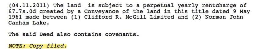
Please note that this search is applicable to properties in England and Wales only. The results of this search will include copies of all documents that are referred to in the Title Register and marked with a NOTE such as ’Copy filed’ or ’Copy in Certificate’. A sample of a note is provided below.
These documents are most often:
Charges – the most common form of charge is a mortgage provided by a bank or other financial institution
Transfers/Conveyances - deeds of transference of the property, or part of the property, which detail all rights or covenants affecting the property
Deeds of Grant
Agreements – maintenance schedules/responsibilities, agreement not to block access to another property, etc
Other Deeds such as Indentures, Assignments, Assents, Plans etc.
Is a Registered Deeds search suitable for history research?
No. The Land Registry is not a historical archive. It is solely a register of ownership and rights & covenants affecting property. The Land Registry holds a copy of a deed if it contains relevant information regarding rights and covenants and if this information cannot be set out in the Title Register.
Are all referred deeds stored with the Land Registry?
No. If relevant extracts of a deed have been set out in the Title Register, the Land Registry does not retain a copy of the original deed. If there is a registered charge in the Charges Register, a copy of the charge is normally available even if there is no NOTE stating this. Some documents are stored partly (e.g. a Conveyance Plan may have been stored but the whole deed has not been retained). This is usually NOTE such as: ‘Copy plan in Certificate’ or ‘Copy plan filed’. The number of deeds stored to a title varies. Some titles do not have old deeds stored as all the relevant information has been included in the Title Register.
Do I need to order a copy of the Registered Deeds?
The Registered Old Deeds are not the main title documents. These are called the Title Register and Plan. Please order the Title Register and Plan if you need a copy of the title deeds. Where there are references to old deeds in the Title Register you are then advised to obtain a copy of any Registered Old Deeds.
About Land Ownership in Scotland
Scotland has two national registers of title and land ownership. These are the General Register of Sasines and the Land Register.
Search sheets for the General Register of Sasines contain written descriptions of title deeds for properties and land which have been registered. These details include the sellers and buyers of the property you are investigating, a written property description, and details of the purchase price paid.
The Land Register is a map-based system (unlike the General Register of Sasines) which contains a property description tied to the Ordnance Map by a title plan, ownership details and conditions which affect the property. (Please note that leases of less than 20 years duration cannot be registered.)
The Land Register is gradually taking over from the General Register of Sasines and is now operational throughout the whole of Scotland. All properties are registered in the Land Register on creation, construction or sale.
Order Title Register and Plan.
Land Registers of Scotland inherited its county-based operation from the old General Register of Sasines’ system. Each county has its own operational date, that is to say, the date when the modern land registration system started in that particular county. Transactions prior to that date are not registered in the Land Register. Operational dates are as follows:
01 Renfrew 6 April 1981
02 Dumbarton 4 October 1982
03 Lanark 3 January 1984
04 Glasgow 30 September 1985
05 Clackmannan 1 October 1992
06 Stirling 1 April 1993
07 West Lothian 1 October 1993
08 Fife 1 April 1995
09 Aberdeen 1 April 1996
10 Kincardine 1 April 1996
11 Ayr 1 April 1997
12 Dumfries 1 April 1997
13 Kirkcudbright 1 April 1997
14 Wigtown 1 April 1997
15 Angus 1 April 1999
16 Kinross 1 April 1999
17 Perth 1 April 1999
18 Berwick 1 October 1999
19 East Lothian 1 October 1999
20 Peebles 1 October 1999
21 Roxburgh 1 October 1999
22 Selkirk 1 October 1999
23 Argyll 1 April 2000
24 Bute 1 April 2000
25 Midlothian 1 April 2001
26 Inverness 1 April 2002
27 Nairn 1 April 2002
28 Banff 1 April 2003
29 Caithness 1 April 2003
30 Moray 1 April 2003
31 Orkney and Zetland 1 April 2003
32 Ross and Cromarty 1 April 2003
33 Sutherland 1 April 2003
The General Register of Sasines in Scotland is one of the oldest land registration systems in the world. However, only sasines from 1905 onwards have been digitally copied only therefore we can only search for data recorded after 1905.
About Land Registers of Northern Ireland
No. The Land Registers of Northern Ireland is NOT part of HM Land Registry. It operates under different legislation and its practices and prescribed forms are quite different.
Since land registration has not yet been extended to all of Northern Ireland, three distinct registration systems continue to operate side by side.
The title to approximately 50% of properties in the province is registered in the Land Registry and the remaining properties are dealt with by the Registry of Deeds. Properties registered in the Land Registry are mainly in rural areas or are properties which have been built, recently, on housing and industrial estates on the periphery of towns, while most Registry of Deeds properties are in established urban areas. The latter are sometimes referred to as unregistered land.
The third register administered by the Land Registry of Northern Ireland is the Statutory Charges Registry. This is a map-based registry which shows the registration of charges on land created by or in favour of government departments and public and local authorities under statutory provisions. This register includes a wide range of subject matters such as planning restrictions, notices relating to water and sewage, notices relating to road turbary regulations, ancient monument preservation orders and statutory conditions arising from home improvements grants.
Order Title Register and Plan.
A folio is an official document which contains a brief description of a registered property together with details of its ownership and any other matters which affect it, such as rights of way, mortgage charges, etc.
There are many matters relating to land and property for which the Land Registry of Northern Ireland is not responsible and does not hold records. For example:
- Unregistered titles
- Matters relating to planning permission, road bonds, tree preservation orders, listed building enforcement notices, declaration of housing action areas, etc., which should be recorded on the Statutory Charges register.
- Land held under a lease for 21 years or less
- Public rights of way
- Rights created before first registration
Most Popular:
Search Tips

![]()
![]()
![]()